Mojini V3 is an online web portal developed by the Revenue Department, Government of Karnataka, to provide land related services such as viewing or requesting land survey documents, viewing sketches, requesting land surveys, and more. This platform, managed by the Karnataka Survey Settlement and Land Records (SSLR) department and monitored by the Karnataka Bhoomi Monitoring Cell of the Revenue Department, aims to make land records easily accessible to the citizens of the state. Below, we have mentioned the services available on the portal and how to utilize them, along with direct links to each service.
How to Request or View Survey Documents in Mojini V3 Portal?
Citizens can follow the process below to either view their existing survey documents available on the Mojini V3 portal or request documents that are not available.
Process to View Survey Documents
Step 1: Go to the Mojini V3 portal and select the “Request for Survey Documents” option, or directly visit the Mojini Citizen Portal.
Step 2: Enter your mobile number, fill out the captcha, and click Send OTP. Enter the OTP received and click Login.
Step 3: In the dashboard, click on “New Request” and select your District, Taluk, Hobli, and Village from the dropdown. Then, enter your Survey Number, Surnoc, and Hissa Number and click Search.
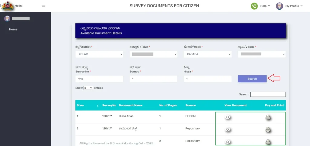
Step 4: All available land documents for the entered survey number will be displayed.
- Click on the eye icon (👁️) under View Document to check the document.
- If you need an original print, click the printer icon (🖨️) under Pay and Print, make a payment of ₹15 per document, and download it.
Process to Request Survey Documents
Step 5: If the required document is not displayed after following the above steps, tick the “Need a document not available above?” option at the bottom of the table.
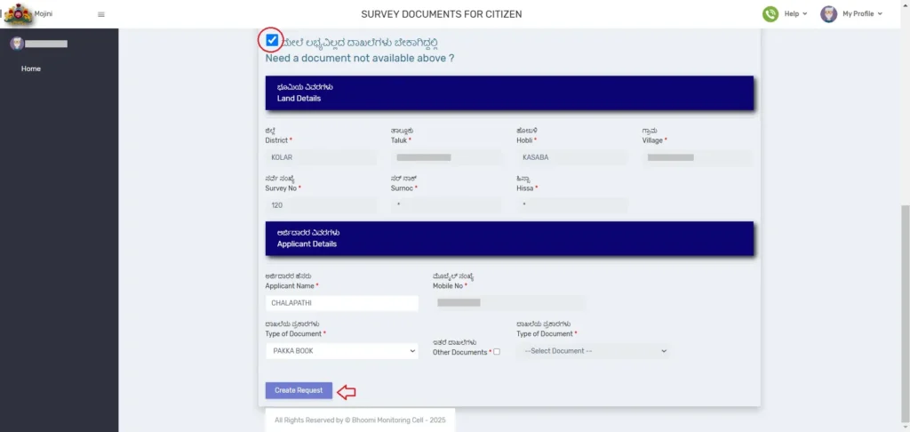
Step 6: Enter the applicant’s name, select the document type, and click Create Request. Once approved, you can view or print the document by following Steps 1 to 4.
ALSO READ: Bhoomi RTC or Pahani 2025 (Download Original Digitally Signed RTC Through i-Wallet)
How to Check Mojini V3 Application Status?
Citizens who have submitted a request for any service through the Karnataka Mojini V3 portal can track the status of their application from time to time by following the steps below:
Step 1: Visit the Mojini V3 portal and select the “Application Status” option available on the homepage.
Step 2: You will be redirected to the application status check page. Here, you can track the status using three options:
- Application Number
- Mobile Number
- Land Survey Number
Step 3: Choose the preferred option and follow the process:
- If tracking by Application Number, select the first option, enter your application number, and click “Get Status”.
- If tracking by Mobile Number, select the second option, enter the mobile number used during the application submission, and click “Get Status”.
- If tracking by Survey Number, select the third option and select details like District, Taluk, Hobli, and Village from the dropdown. Click “Go”, then choose the Surnoc and Hissa Number, and click “Get Status”.
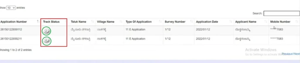
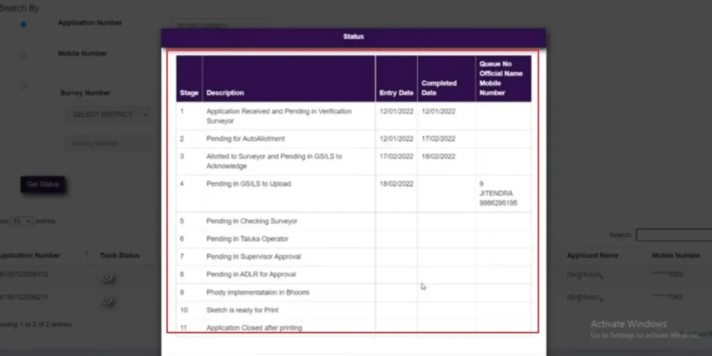
Now, the application details submitted by you will be displayed. Under the Track Status section, you will see an eye icon (👁️) next to your application number, click on it to view the detailed status. This will show the current stage of your application and the number of remaining stages until completion.
Services Available on Mojini V3
The Mojini V3 portal offers various services related to land records and surveys, as listed below.
1. Application Status: This service allows users to track the status of their application for services requested through the Mojini V3 portal by entering the application reference number.
2. Allotment Status: Citizens can check the allotment status of land by providing their application number. This service ensures transparency in land allocations.
3. View Sketch: Users can access different types of land sketches, including:
- 11E Sketch (Pre-Mutation Sketch) – Required for mutation processes.
- Alienation Sketch – Used for land conversion.
- Phodi Sketch – Required for land division.
4. Revenue Maps: This service allows users to view village maps across Karnataka, including within BBMP limits. It helps in understanding land boundaries and ownership details.
5. Dispute Cases: Citizens can check dispute reports related to land records. This feature helps identify ongoing legal or ownership conflicts before purchasing or using land.
6. MIS Reports: The Management Information System (MIS) reports provide detailed insights into land surveys and other administrative data. These reports are particularly useful for government authorities and land analysts.
7. Circulars: Users can access official circulars and notifications issued by the Survey Department. These circulars provide updates on land policies and regulations, so it is advisable to check this section regularly.
8. Request for Land Survey: Citizens can apply online for various land surveys through the Mojini V3 portal, including:
- 11E Sketch (Pre-Mutation Sketch) – Required for property mutation.
- Land Conversion Sketch – Needed for converting agricultural land to non agricultural purposes.
- Haddubasthu Sketch – Used for marking land boundaries.
- Thathkal Podi (Urgent Phodi) – A fast track service for land division.
9. Request for Survey Documents: Users can request essential land survey documents, such as:
- Tippan – A field measurement document showing land dimensions.
- Pakka Book – A register containing land survey records.
- Atlas – A collection of land maps useful for legal, financial, and ownership verification.
- Akarband – A document that records land classification and ownership details.
- FMB (Field Measurement Book) – Contains detailed sketches and measurements of surveyed land.
- Survey Prati Book – A record of past survey details and modifications made to land records.
To request the above mentioned survey documents through the Mojini V3 portal, an applicable fee of ₹15 must be paid online.
10. View Survey Documents: Once the requested survey documents are approved by the revenue department, users can view and download them directly from the portal.
11. View Mojini Reports: This section provides access to various reports related to land surveys and ownership details, helping users make informed decisions regarding land transactions.
Mojini V3 Help Desk Number
☎ +91 82 7786 4065 (Mysore Division)
☎ +91 82 7786 4067 (Banglore Division)
☎ +91 82 7786 4068 (Kalaburagi Division)
☎ +91 82 7786 4086 (Belagavi Division)
For any queries related to the services on the Mojini V3 portal, citizens can contact the respective help desk numbers for their division between 10:00 AM and 6:00 PM.